MAPS - Various Locations Mentioned
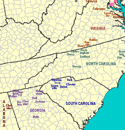
Note: Some locations for reference purposes only.
For additional maps--link to
- www.mapofus.org/united-states/
Interactive map of states and territories over time as well as links to antique maps and atlases
For each state - interactive map of county formation as well as links to antique maps
- www.libs.uga.edu/darchive
/hargrett/maps/1794n4.jpg
1794 map of southeastern United States - www.archivesindex.sc.gov/guide
/CountyRecords/countymap2.htm
Maps Tracing the Formation of Counties in South Carolina
links to 14 different maps showing county and district divisions spanning 1682 to present - sites.rootsweb.com/~gatttp
/maps/formationmap.htm
Georgia County Formation Maps
Map showing county boundaries in Georgia (1758-1932 for 59 dates)
Please refer to these map link sites for actual boundary information. The boundaries on the maps at this site are for general information and are approximate.
Historical Dates of Interest
| 1656 | Old Rappahannock County formed in Virginia |
| 1692 | Old Rappahannock County in Virginia split to form present-day Richmond and Essex Counties |
| 1754-1763 | French and Indian War |
| 1775-1783 | Revolutionary War |
| 1784 | Franklin County in Georgia formed. |
| 1786-89 | Greenville and Pendleton Counties in South Carolina formed from land taken from Cherokee during American Revolution. (Cherokees supported the British.) |
| 1796 | Jackson County in Georgia formed from part of Franklin County. |
| 1805 | Georgia "Federal" Road through Cherokee Territory from Ringgold to Tate completed |
| 1806 | First Georgia Land Lottery held |
| 1807 | Second Georgia Land Lottery held |
| 1813-14 | Creek War |
| 1815 | Hightower Road from the Chattahoochee River to Cartersville and then west to Euharlee, Georgia. One of three or four Alabama Roads |
| 1818 | Habersham, Hall, and Gwinett Counties in Georgia formed. Hall County formed mostly from Jackson County. |
| 1820 | Third Georgia Land Lottery held |
| 1821 | Fourth Georgia Land Lottery held |
| 825 | Creeks removed from Georgia |
| 1827 | Fifth Georgia Land Lottery held |
| 1828 | Gold discovered in North Georgia |
| 1830 | Original Cherokee County formed in December |
| 1832 | Sixth Georgia Land Lottery (Cherokee Lottery) held. Land had not been ceded to Georgia from Cherokees.
In December Cherokee County divided into ten counties--Cass, Cherokee, Cobb, Floyd, Forsyth, Gilmer, Lumpkin, Murray, Paulding, and Union. |
| 1832 | Seventh Georgia Land Lottery (Gold Lottery) held |
| 1835 | Members of the Ridge or Treaty Party sign Treaty of New Echota without the approval of the Cherokee National Council |
| 1838-39 | Cherokee "Trail of Tears" |
| 1860-61 | Southern States secede |
| (5/5-9/4) 1864 | Sherman's March from Chattanooga to Atlanta |
| 1865 | Last organized group of Georgia Confederate soldiers surrendered at Kingston, Georgia |
| 1917-1918 | War World I (US) |
| 1941-1945 | War World II (US) |
For more extensive history-- link to
- ngeorgia.com/history
About North Georgia - www.cherokeecountyga.org
Georgia GenWeb site for Cherokee County - roadsidegeorgia.com/county
/cherokee.html
History of Northwest Georgia and links to the counties formed from the original Cherokee County (all of northwest Georgia)
Note: Links will open in a new tab/window. This window should stay open.